During our travels we have been involved with volunteering for Nationals Parks in South Australia and Western Australia. It started out as an opportunity to give back during what we correctly assumed would be a lot of time spent in national parks, but what we didn’t realise is that it would lead to some of our most cherished memories on the road. Our time in Purnululu National Park in Northwest Australia was no different; we had such a unique experience that gave us the opportunity to explore the park thoroughly with the help of insider knowledge from the rangers and have some pretty special experiences that most visitors to the park will never see.
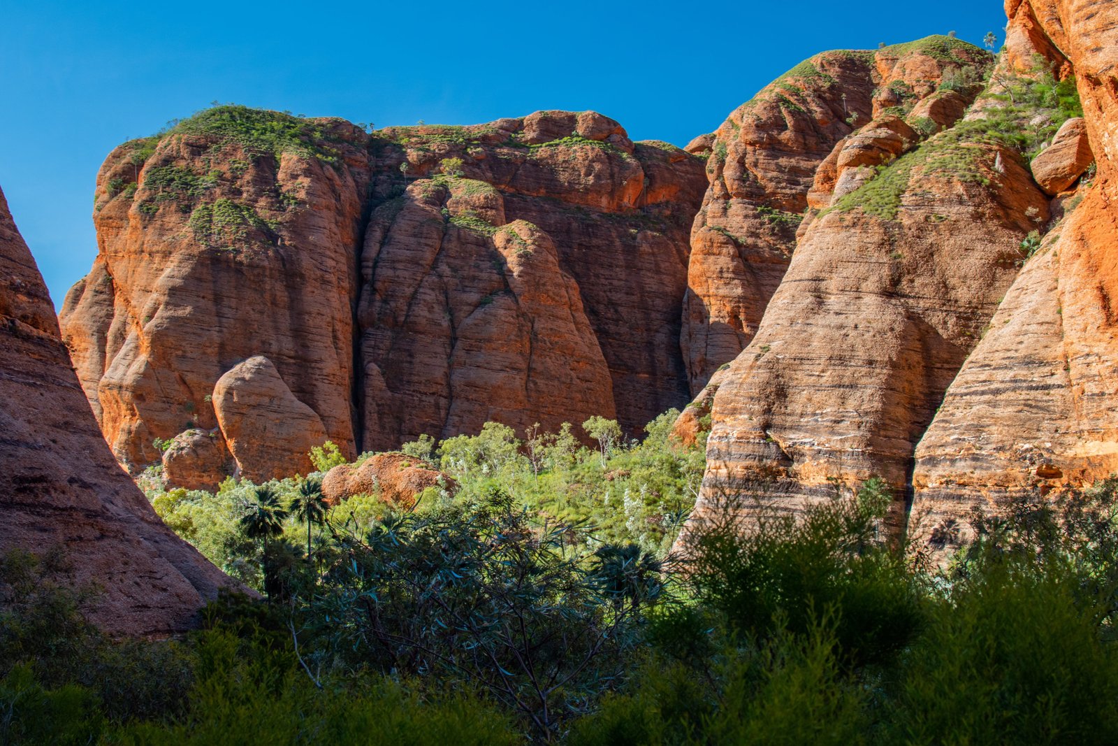
Purnululu National Park, previously known as Bungle Bungle National Park, was added to the World Heritage list in 2003. It first became known to the outside world when a TV crew documented the “discovery” of this “lost city” in outback northwest Australia in 1983. Going back much, much further, however, the Jaru and Gija indigenous people have claimed traditional ownership of these lands for thousands of years. The origin of the name “Bungle Bungle,” or “Bungles” for short, is still a bit of a mystery, but our favourite explanation goes something like this: a station owner was heading south to meet up with a salt mine owner who had “bungled” his business, and the station owner “bungled” the directions there and got lost; with a bit of Aussie humour added in, the two settlers decided to call the area Bungle Bungle after the two bungles they had made prior to getting there. “Purnululu” is an indigenous word for “sandstone”, after the beehive-like domes made of sandstone that have made this place famous. The sandstone domes are quite striking and unique, but there is so much more to this park that makes it well worth a visit.
Our original volunteer assignment was to be a campground host for Walardi campground for the month of April, right when the park opened to the general public as it usually does every year. This year, however, happened to be one of the wettest wet seasons in years for the Kimberley, including a massive 100ml dumped overnight in mid-March in the catchment that included Purnululu; therefore, the opening of the national park had to be delayed due to the roads becoming inaccessible to the general public. We weren’t entirely sure we would be able to enter the park on 1 April as planned but after a chat with the rangers, we got the all clear to come through. Our only warning was to watch out for the third creek crossing, which was extremely boggy and had been the undoing of several vehicles already. We got through with a bit of expert 4WD’ing from Marc and ended up being one of the last cars to get through that crossing without getting stuck.
Now we had arrived to campground host in a national park that was still shut to the general public, meaning no campers to host! It turns out there was still plenty for us do to, including lots of whipper-snipping (we will never take a cleared path for granted again!), as well as painting, putting up signs, and generally just being an extra set of hands for the rangers. When were weren’t helping the rangers with various jobs, we basically had free rein of the park which meant we got to see all the attractions numerous times and usually with no one else around – imagine having Cathedral Gorge all to yourself or floating in a swimming hole with the domes reflected on the water’s surface; it was nothing short of magical. Not only that, we got permission to visit ancient Aboriginal art sites and permanent waterholes, truly a special experience.


The various sights of Purnululu can be broken down into north and south sections, with the road from the information centre bisecting them. Starting with the north…
ECHIDNA CHASM
Echidna Chasm is the northernmost attraction of the park, located approximately 20km from the visitor centre. It involves a short 1km walk into a chasm with 200m high red stone walls. Echidna Chasm is beautiful any time of day but it is most spectacular around 11-11:30am when the sun is directly overhead and shines bright light into the dark chasm, creating a stunning contrast.

MINI PALMS
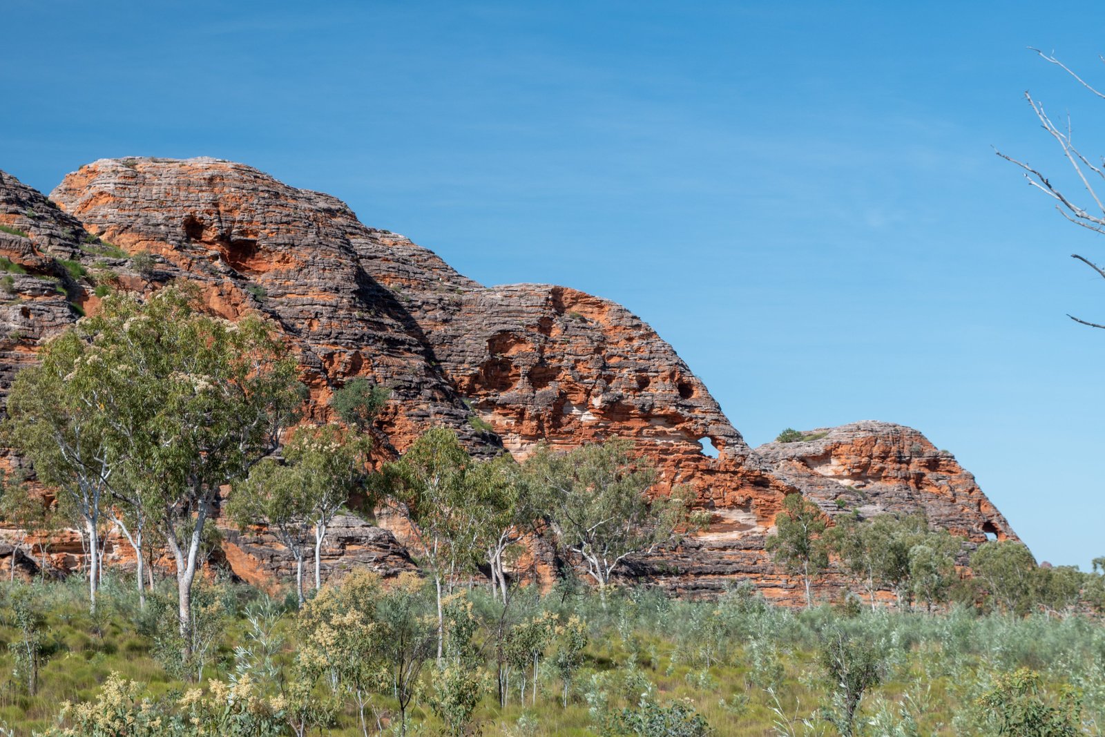
Continuing further south is Mini Palms. This walk was named after the tiny palm trees that used to cover the gorge floor at the end of the walk. Unfortunately in 2011 a massive flood event decimated these trees; nevertheless, they are slowly but surely growing back. The walk leaves from the Bloodwoods carpark, which itself offers a scenic lookout. The 4.4km return walk is more challenging than Echidna Chasm and involves walking on a rocky creek bed and climbing up and around large fallen boulders and up steep steps. It is one of the best places to appreciate the Livistonia palms, which are endemic to the region. The first part of the walk is exposed, then it becomes shaded by the high gorge walls.

HOMESTEAD VALLEY
We feel Homestead Valley is one of the more underrated walks of Purnululu. This walk is also 4.4km return but is exposed for a majority of it, so it’s best done first thing in the morning. At the end of the walk you’ll reach a valley surrounded by monumental rock formations dotted by Livistonia palms, spinifex, and other greenery. You can read about the history of this place and speculations as to why this area has been named Homestead Valley from the signage at the lookout. From our time with the rangers, we actually know the most likely answer to this: on a wall hidden from the main track is a collection of Aboriginal art. Amongst this art is a charcoal drawing that looks like it’s been done by a settler, likely a child, of a homestead.
The Escarpment walk, which is 3.6km one way from Echnida carpark to Bloodwoods carpark, connects all of the other walks mentioned above. It is best done first thing in the morning as it is very exposed and will get full afternoon sun.
STONEHENGE
Stonehenge can be a bit of a disappointment to people expecting a rock formation similar to the UK version; however, this is not the case. Stonehenge is simply a short, level walk around bush land with signs explaining the traditional use of various plants by the local Aboriginal people. Even the rangers are unsure as to why it has the name Stonehenge; all that’s known about the name is that it’s a remnant of pastoralist times. The walk is still very informative and worth a look, but don’t expect any grand rock formations to admire!
KUNGKALANAYI LOOKOUT
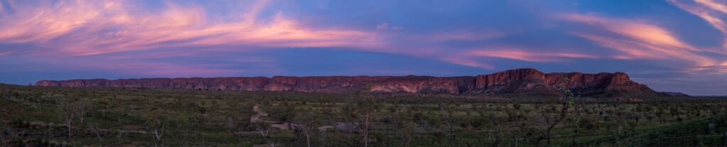
For the northern section of the park (and probably the entire park for that matter), this is the best spot to see the sunset. The way the colours change over the Bungle Bungle Ranges as the sun sets behind you is mesmerising. Often just after the sun sets behind the horizon, the sky really lights up with all sorts of brilliant colours. It’s a must do at least once during your stay!

Now onto the southern section; the track to all the landmarks mentioned below starts at the Piccaninny carpark.
THE DOMES
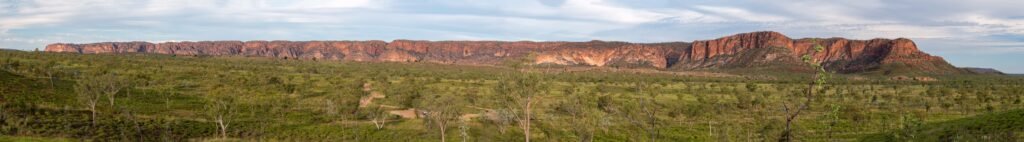
As previously mentioned, the Domes are the main attraction of the park and what made it famous. They are the result of weathering over 20 million years slowly layering and shaping these beehive-like structures. They are made up of orange and black bands; the black bands are rich in Cyanobacteria, marking a period of flood or good wet, and the orange bands lack Cyanobacteria, meaning a time of drought. You’ll see them well before you get to the carpark and walking track as suddenly the range morphs into these striking domes. Keep an eye out for Elephant Rock on the road in; you’ll very quickly see how it got its name.
First light is a great time to see and photograph the domes, as the rising sun bathes them in a golden glow and really brings out the differing layers. The easy 700m loop trail takes you amongst these domes to be able to appreciate them up close.

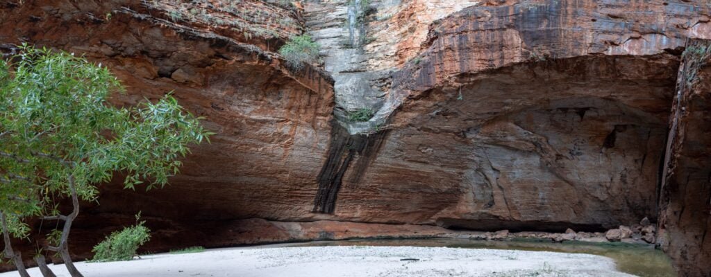
CATHEDRAL GORGE
Continuing on the walking trail from the Domes for another 1km or so leads to the impressive Cathedral Gorge.
Walking through the narrow gap in the gorge until suddenly it opens up into this cavernous amphitheatre is quite awe-inspiring. Usually until late in the dry season there is water in the middle; this is said to be the eye of the Rainbow Serpent and will frequently change in colouring and clarity. Tip: there is a small overhang to the right of and up from the walking track maybe 50-100 metres before arriving at Cathedral Gorge that has a small collection of Aboriginal rock art; it is marked but easily missed.
PICCANINNY CREEK LOOKOUT
Piccaninny Creek Lookout is another of the lesser known spots that we highly recommend. It is a short 2.8km return walk from the carpark, through Piccaninny Creek and winding up to the top of a fantastic lookout. Here you get expansive views of the creek, domes, and surrounding countryside. It makes a great place to see the sunrise, watching the light change over the domes and listening the local fauna coming to life for the day.

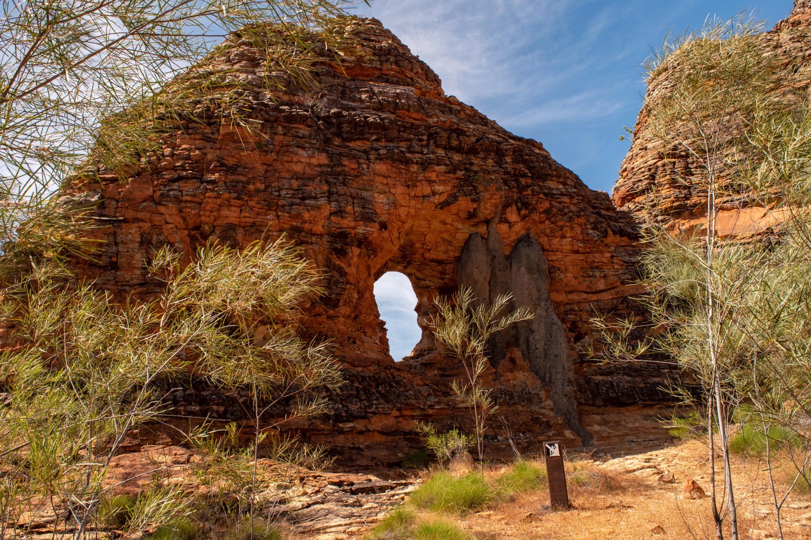
WHIPSNAKE GORGE
This is the longest day hike at 10km return. Though not quite as impressive as Cathedral Gorge, Whipsnake Gorge is still beautiful and green thanks to the permanent waterhole there. On the track to the gorge you will pass a short turnoff to The Window, a cool little rock formation in the shape of, well, a window.
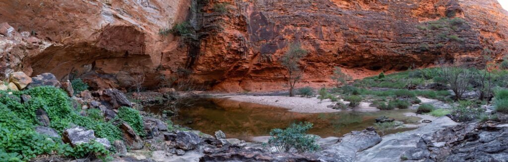
PICCANINNY GORGE HIKE

Piccaninny Gorge Hike takes you past Whipsnake Gorge, along Piccaninny Creek to a set of five side gorges known as The Fingers. It is a Class 5 or 6 walk, depending on which sign you read; it is an unmarked walk (although fairly easy to navigate as you just follow the creek bed) and involves walking on uneven surfaces and, depending on how wet the track is from the wet season, may involves some clambering up and over rocks to get past waterholes. You are required have a sat phone or PLB with you for the hike and can hire one from the visitor centre if needed. The information centre has a great brochure about the hike with lots of helpful info in it. While this walk can be done as a long day hike, two nights is probably the ideal: one night to get to camp just pas The Elbow, which is 8km (doesn’t sound like much but it’s not always the easiest terrain to trek), then the next day as a full day to explore the Fingers, before returning the following day. There is a reliable water source just before the start of the Fingers, called Black Rock Pool (no swimming allowed to keep it as clean drinking water!), but it is wise to check the status with the rangers, especially if doing the walk late in the season. We were the first hikers to do the trek for the season, but there was still so much water in the gorges that we were limited with how much we could get to. Each of the five Fingers is about 1-2km long so there is lots of exploring to do, enough to easily fill a full day (or more)! One of our favourite experiences was sitting outside our tent at night, with the Milky Way rising behind a set of domes, and a dingo’s lone howl in the distance…absolutely breathtaking!

PURNULULU FROM THE AIR
The Bungle Bungle Range covers a massive 45,000 hectares, which is well over 100,000 acres. What you see from the ground is only a fraction of that, so to get a full picture of this spectacular landscape, a scenic flight is a must-do; this can be done either by plane or helicopter. Scenic flights usually leave from nearby Kununurra, and some do have the option of landing and exploring the park via 4WD. The other option is a scenic helicopter ride with Helispirit. There are three options if leaving from Bellburn, the airport in the southern end of the park: 18 minute, 30 minute, and 42 minute flights. We opted for the 30 minute flight, which gives you a great overview of the domes, as well as the northern ranges, including seeing the Fingers on the Piccaninny Gorge hike from the air. We cannot recommend it highly enough!

Accomodation and Accessibility
Probably one of the biggest barriers to many people wanting to visit Purnululu is the 53km unsealed road in from the highway. It has so much of a reputation that you can even purchase stickers in the Purnululu info centre reading “I survived the road into the Bungles!” Dual axle caravans are prohibited, and honestly even if they weren’t, there’s no way we would be bringing our van along that rough and winding road. Because of this, a lot of people stay outside the park, for example at the caravan park just off the Highway, and day trip into the park. While it is doable, we feel you need at least a couple nights in the park to fully appreciate it. Kurrajong campground in the north and Walardi campground in the south both have plenty of room for tents, campervans, and single axle trailers. There is even talk of adding a third campground in the near future. Otherwise, you can stay in a lovely eco cabin at the Bungle Bungle Savannah Lodge in the southern end of the park, complete with pool and bar/restaurant.
The park is usually open April to December (weather permitting of course!). Days are usually hot, and nights can get very cool, so pack for all weather. No fires are permitted in the park so you’ll need to be prepared to rug up if visiting in the winter.
If you are interested in volunteering with national parks, each state has its own program. Here is the link to the WA Parks program:
https://www.dbca.wa.gov.au/parks-and-wildlife-service/volunteering-with-parks-and-wildlife
Many people skip Purnululu National Park on a visit to the Kimberley or have it low on their priority list, but it is so rich in natural beauty and Aboriginal culture that it really should be on everyone’s must-do when visiting this region. We were sad to leave after spending an amazing month here but were pretty excited for our next adventure: tackling the iconic Gibb River Road!