While the western portion of the Gibb River Road has most of the well-known highlights of the area, the eastern section has some iconic gems too. And to top it off, the Mitchell Plateau, home of Mitchell Falls, is the most spectacular of them all.
MITCHELL PLATEAU
For those with the time and gear, the Mitchell Plateau simply cannot be missed when visiting the Kimberley. For those with caravans, they are asked/strongly encouraged to be left at Drysdale Station, and after doing that track and seeing broken down caravans on the side of the road, we entirely see why.
Munurru (King Edwards River) is a great stop-over when coming from or going to Mitchell River National Park.

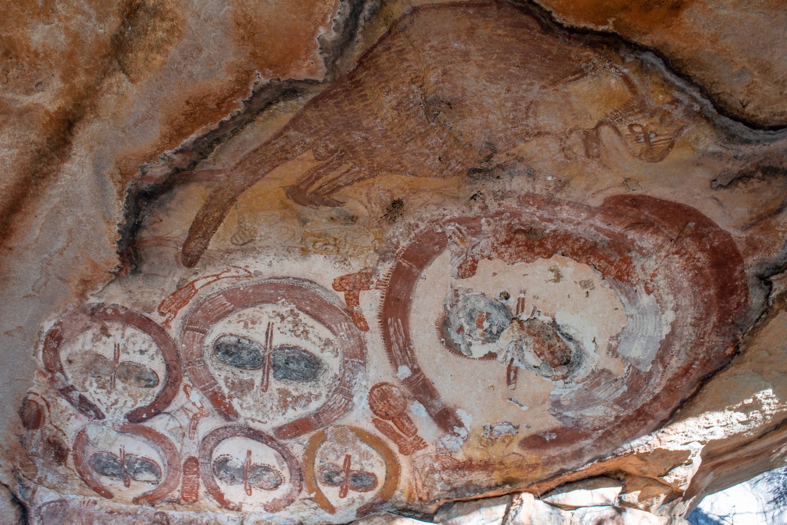
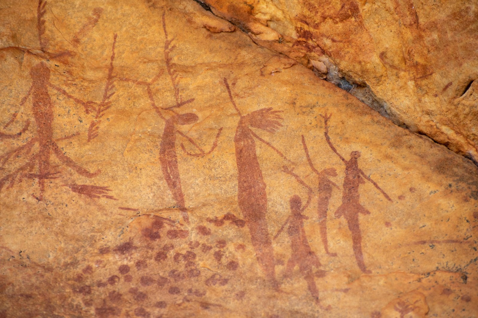
There is a beautiful camp along the King Edwards River with a great swimming hole, but most importantly there is a huge number of Aboriginal artefacts in this region. Lots of Aboriginal art, most of which is sign-posted and easy to find, is dotted throughout the area; some of this art has been dated at 30-40,000 years old! The most common and striking is the Wandjinas; these are traditionally believed to the resting place of ancient spirits. You can also find human remains here, as some of these places also served as burial grounds, so please be respectful when visiting these places. There is a book you can purchase at Drysdale Station which offers lots of information on the artwork and the history of the place. We didn’t get one but wish we had.
Further north along Kalumburu Road are two raved-about beach camps called McGowans Island and Honeymoon Bay. We didn’t make it up on our visit as the road north of the Mitchell Falls turnoff was closed, but apparently there are some epic beaches and fishing opportunities along the northern coastline.
To get to the Mitchell Plateau and Mitchell River National Park, you will need the Ngauwudu Road Zone Pass. In 2021, the cost was $45 per person. It’s easy to do online, or it can be organised at local information centres such as the Derby Visitor Centre. Now be warned: this rated in the top three of the WORST roads we’ve come across during our travels. It was corrugated and winding, which is a bad combination; if you have a straight corrugated road you can ride over the top of the corrugations at a decent speed, but that would just be reckless on this road so you have to cop every bump. But trust us, it is worth it!
The only option for camping in the Mitchell River National Park is the Parks-run campground (Punamii-unpuu). It wasn’t too busy when we visited so there was plenty of room for everyone to spread out, but I can imagine it can pack out during the busier months. Our advice when picking out a camp: try to go as far away from the helipad as possible; they start up fairly early in the morning and go consistently throughout the day until sunset, so the noise can be a bit bothersome. As far as facilities, there are drop toilets and water taps (boiling the water prior to drinking is recommended). That’s it, so you’ll need to be fairly self-sufficient to stay here. Nearby Mertens Creek is great for a quick cool down close to camp.
Many people opt to do a helicopter ride to Mitchell Falls. We HIGHLY recommend making that only a one-way trip; if not, you’ll miss out on so many amazing places found along the walking track to Mitchell Falls. It is by no means a challenging walk; it is 8.6km return, well-marked with a bit of rougher terrain and boulder-climbing closer to the main falls. If walking both ways, bring food as it can take a good part of a day to walk there and back, with time to enjoy each stop.

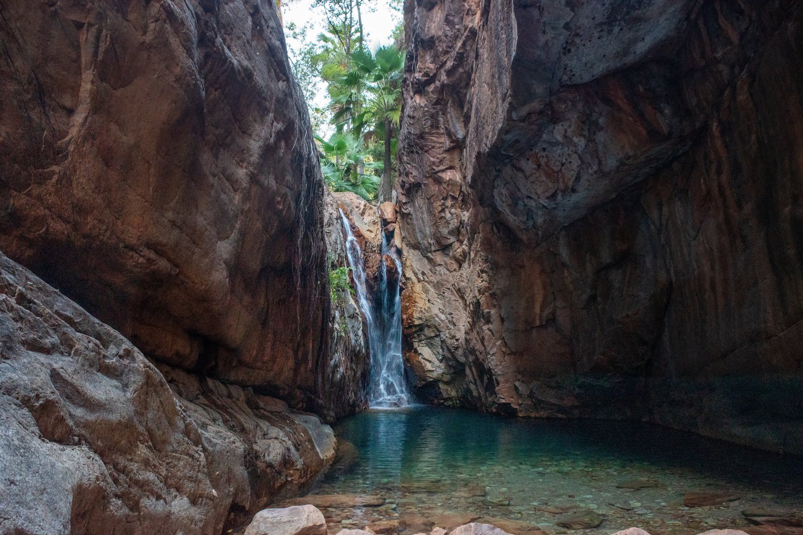
Little Mertens Falls, a 1.6km return walk from the campground, is an obligatory stop along the way (well, we think so at least). The falls are beautiful and make the perfect sunning or cooling off spot, but it is the Aboriginal artwork found here that is really remarkable. From what we’ve seen so far in Australia, it’s some of the best rock art you can see in the entire country. To find the art, look along the track down to the lower pool for a track branching off to the left about midway. Otherwise, walk or swim to the left of the falls and follow the rock wall along. Take your time when looking at the art; from our experience we find the longer you look, the more you see. And there is lots to see here!
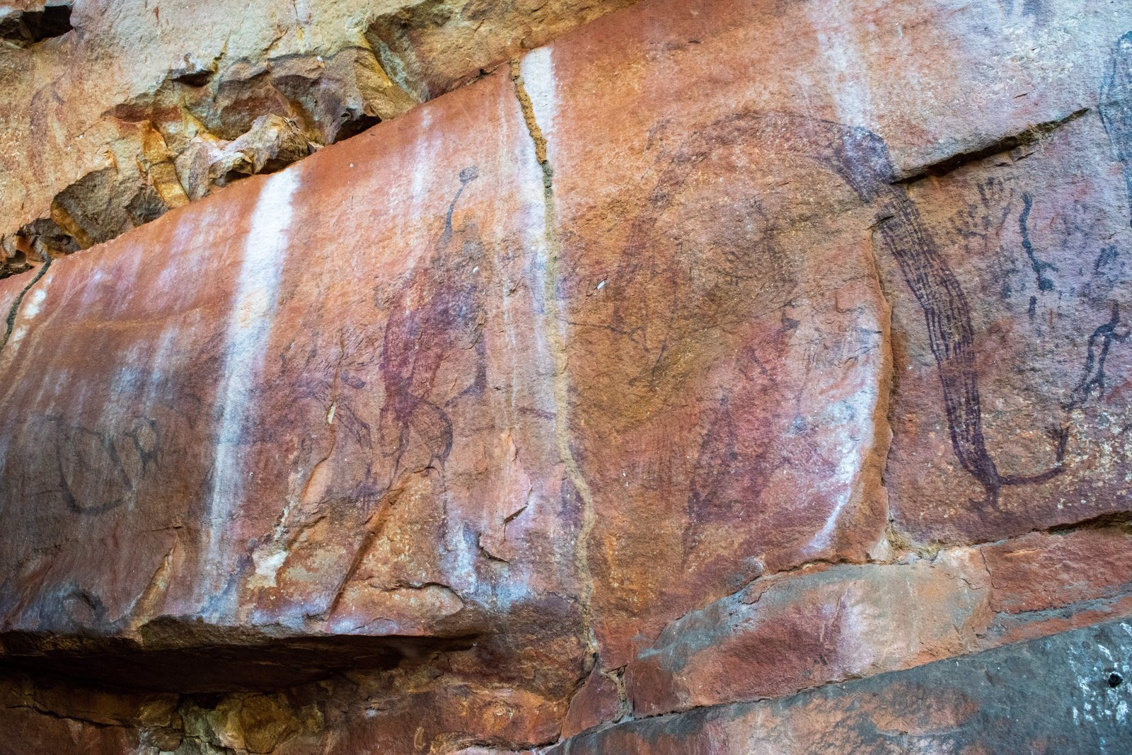
Continuing on the main path for a bit longer, keep an eye out for another small pool to your left. This is another good option to cool off, and if you look across to the rock wall on the other side, you’ll spot a unique style of Aboriginal rock art known as Gwion Gwion paintings (also known as Bradshaw paintings), which is found only in the Kimberley region of Australia.
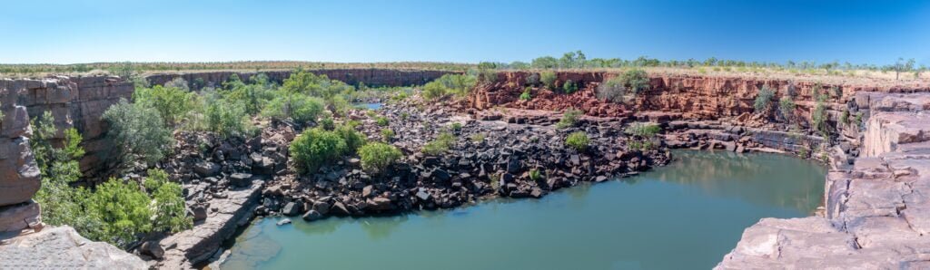
The next highlight along the walk is known as Big Mertens Falls, where the rocky plateau suddenly drops into a dramatic gorge with a beautiful waterfall. Even though it’s not the “main attraction,” it’s worth taking a bit of time admiring because it is still quite magnificent.
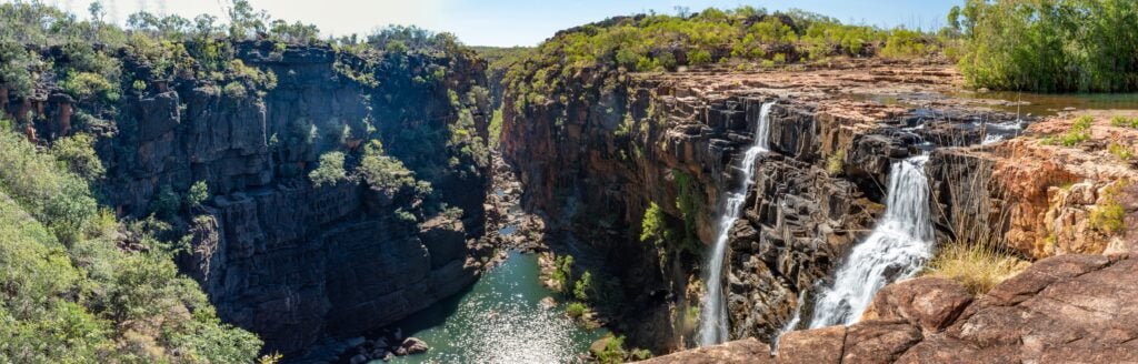
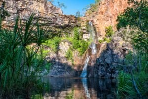
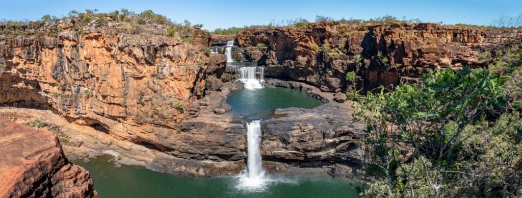
Last but most certainly not least is punamii-unpuu (Mitchell Falls). After the most challenging leg of the walking track, it brings you out over the top of the falls. It’s quite amazing that for all the grandeur of the falls, there is relatively little water flowing through at the top!
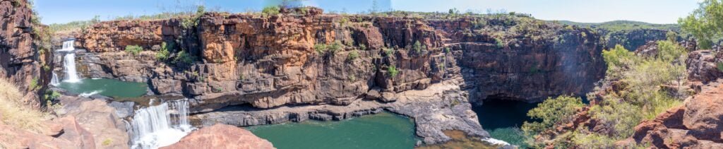
A track to the right of the waterfall leads to great views over the top tiers of the falls, but to get the full effect, you’ll need to cross the river upstream and continue walking a little bit longer. The feelings that arise upon viewing this spectacular falls in all its glory are difficult to put in words. It is grand, sacred, awe-inspiring, magical, and we just felt so incredibly lucky to be there. There are a few different vantage points to get great views of the falls, so take some time to explore around the plateau. Additionally, you can find a few, croc-free areas to have a cooling dip.
If you have a bit of spare time during your stay at Mitchell River National Park, another point of interest is aunauyu (Surveyor’s Pool). A short, fairly easy walk (2km return) leads to small gorge, with a pretty waterfall and pools below. According to the local Wunggurr people, the white rocks along the pool are the eggs of the Rainbow Serpent; therefore, it is asked that you do not swim in the lower pool. Oh yeah, and there’s a risk of estuarine crocodiles!

MT ELIZABETH STATION
Mt Elizabeth Station is one of the few working cattle stations along the Gibb that you can visit. Unfortunately for our visit in May 2021, timing was not on our side and the attractions of Mt Elizabeth were still not accessible due to the significant wet season that year. However, visitors often rave about Wunnumurra Gorge for its picturesque waterhole and abundance of Aboriginal art. And if it reopens to the general public, the Munja Track would be an epic remote 4WD adventure.
ELLENBRAE STATION
Ellenbrae Station isn’t usually high on people’s lists for stops along the Gibb. While you won’t find any breath-taking gorges or swimming holes here, it is still worth at least calling in. Ellenbrae has lovely green lawns (a welcome break from all the red dust!), a natural campground with quirky amenities, a couple small waterholes, and quite possibly the best scones in the Kimberley!
BINDOOLA FALLS
About 16km before the turn-off to Home Valley Station on the north side of the Gibb, completely unmarked, is a track that leads to Bindoola Falls. The falls themselves don’t last long into the dry season, but it is still an impressive area to explore and despite a resident freshwater croc or two, is considered safe for swimming.
HOME VALLEY STATION
This was another well-known Kimberley station that we didn’t get to due to a delayed opening in 2021. That year, it wasn’t even certain if they were going to open up at all but by the second half of the season they were back in full swing. Home Valley is one of only two stations that offer powered campsites (El Questro being the other one) at their Homestead. The other camping option is their bush-style camping along the Pentecost River. In addition, they have plenty of tours on offer and a very popular bar and restaurant.
THE PENTECOST
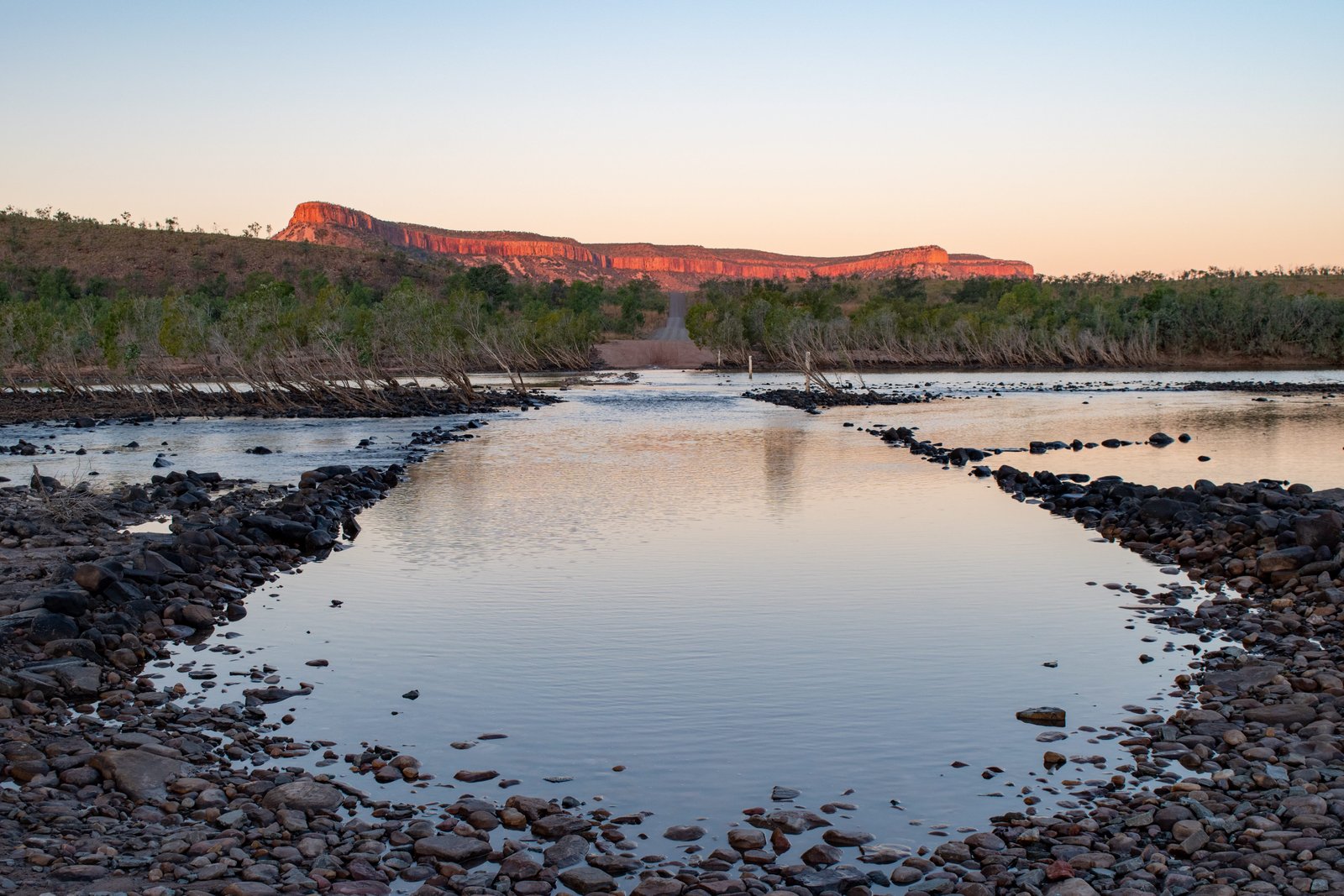
The Pentecost River can either make or break your GRR trip. Until the waters of this river recede enough after the wet season for a safe crossing, the GRR is inaccessible. Now this used to be an epic (read: somewhat dangerous) water crossing, but after a particularly dry year a few years ago, the track’s been built up so it’s nowhere near as deep and treacherous as it used to be. Nevertheless, the earlier in the season it is, the deeper it is so be aware! It is a tidal river, with saltwater on one side and freshwater on the other. It is definitely croc territory so no swimming (although you’ll often see locals going in for a quick dip). Make sure you’re ready with your camera or drone to get that iconic shot of the car crossing the river with the Cockburn Ranges in the background, especially spectacular at sunset as the ranges glow a beautiful Kimberley red.
On the eastern side of the river is an unofficial free camping area; be careful, the sand can be boggy…we know from personal experience! Along the back of the camping area runs the start of the Karunje Track, which will take you the back, and more adventurous, way to Wyndham. We were keen to do this track but it was too early in the dry season so the track was still fairly treacherous, particularly when travelling alone. Call Digger’s Rest for the latest update on the state of the track.

EL QUESTRO STATION (ELQ)
Being east of the Pentecost, El Questro Station is usually one of the first places to open up after the wet season as it is easily accessible from Kununurra. There is a decent water crossing to access the station, but this recedes fairly early; check accessibility with the station beforehand. Campsites are available at the homestead, but for the ideal camping experience, it is worth the extra cost for a private riverside camp. You need to be a bit more self-sufficient though, as all you’ll have are a patch of grass, a fire pit, and (hopefully, but not always) a nearby drop toilet. You can still use all the facilities at the homestead, but these spots are not caravan-accessible.

Similar to Home Valley, there is an abundance of tours and activities to do, as well as plenty of self-guided option. For those with a high-clearance vehicle and a moderate level of fitness, El Questro Gorge is a must. You’ll have to cross a fairly deep river crossing to get to the trailhead. From there it’s a challenging walk, particularly the second half, that involves lots of clambering up and over boulders but the idyllic waterfall at the top makes it well worth the effort.
Amalia Gorge is another nice option for a hike, best seen early in the season as the waterfall dries up fairly quickly. The walk itself involves a bit of climbing up a small gorge wall about halfway; otherwise it is an easy walk. Be warned, the pool at the end is icy cold!

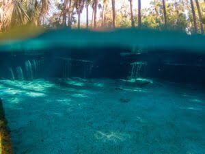
For those who want something a bit more low key, Zebedee Springs is the way to go. A short, easy walk leads to a multitude of thermal pools under the shade of Livistonia Palms, perfect for ultimate relaxation. Usually the pools higher up are less busy, and they’re also warmer. Be aware that Zebedee Springs is only open to the general public 7am-12pm; from then on it’s only accessible for private tours.

Lastly for those with 4WD experience, there are a few 4WD options to explore the park further. Pigeon Hole Track has great views from its lookouts, but Branco’s Lookout offers the most superb views of Chamberlain Gorge, El Questro, and beyond. Saddleback Ridge, which starts close to the private riverside camps, also has a great lookout platform and is particularly popular at sunset.

Separate from the ELQ area but still under its umbrella is Emma Gorge. This is a pretty popular walk as the trailhead is the most easily accessible from the Gibb, even caravans can easily park there. The first part of the walk takes you through the gorge, mostly along the riverbed, until you get to an enchanting blue pool. From there, the hike gets a bit steeper, until you reach the dramatic, lush walls of Emma Gorge. The waterfall is usually only but a trickle, but the area is impressive nonetheless. The main pool, similar to Amalia, is very cold as it gets little sunlight, but if you want something a bit more pleasant temperature-wise, there are thermal waters around rocks to the right. It’s by no means hot, but compared to the ice bath of the main pool, it is nice and warm.

And there you have it folks, a comprehensive guide to the Gibb River Road, the Kimberley’s best 4WD adventure! This turned out to be the last place we explored in WA. Next up, we make our way to Darwin, up in the Top End of Australia!