Ever since we had moved to Melbourne almost eight years ago, we have had our sights set on reaching the southernmost point of mainland Australia. The only other compass point we had reached by this time was the easternmost point in Byron Bay, NSW, which we really only happened upon by accident (“Hey, let’s go check out that lighthouse!” “Oh look, this is the easternmost point of mainland Australia…cool!”). The southern point seemed a bit more adventurous to reach: you need to trek through the beautiful, somewhat hilly Wilson’s Promontory National Park for about 15 km, which is comfortably done as at least an overnight hike. When we first visited Wilson’s Prom back in 2010, I remember looking curiously and longingly at the path leading south from Telegraph Saddle, wondering what sort of wondrous scenery awaited, but we simply didn’t have the gear to make the journey at that time. Over the years, we gathered everything we would need to make this hike happen and finally, in November 2018, we were ready to go. We picked Melbourne Cup weekend, which can be a two-day weekend turned into four quite easily thanks to some horse race, which meant we could go at a more leisurely pace for our first multi day hike. The night before, we packed up all our gear, a bit nervous about the weight (“I’m going to be carrying how much on my back for four days??”), and settled in to enjoy our last night in a comfy bed for the next few days.
DAY 1
As the first day’s hike was a shorter one, we woke up at a reasonable time to take off from Melbourne. The drive to Tidal River is about 3.5 hours from Melbourne and a lovely one once you trade the built-up, crowded city and suburbs for the rolling hills of the Gippsland. Once we arrived at Tidal River we went to the information centre to check in before setting off to our first night’s destination, Oberon Bay. We were immediately warned about the gale force winds blowing that day, which we had taken note of as they occasionally rocked the car on our drive down. Not the most ideal for a walk along an exposed coastline, but oh well, we were committed now. Once we checked in, we parked at the designated overnight hiker’s car park, hoisted our bags onto our backs and set off.
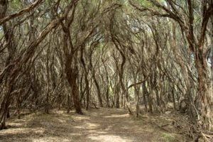
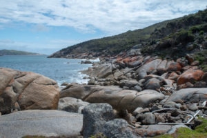
Despite the unrelenting, blustery winds, the 7.6 km walk from Tidal River to Oberon Bay was stunning. We begun the walk on a dirt path through a thicket of coastal tea trees and then suddenly, as if there was an invisible line drawn by nature itself, the landscape completely changed within a couple of steps to sandy trails lined by flowery bushes.
Throughout the walk, we weaved in and out of picturesque bays, which would have been quite inviting for a swim had it not been for the rough surf being churned up by the powerful winds. After a last long stretch of walking on an exposed beach that seem to go on for eternity as we were being constantly blasted by the winds, we made it to the Oberon Bay campground.
The camp has many spots tucked away in various nooks and crannies so we took our time to look around and find that ideal spot. Normally, one of the spots near the beach and creek would be magical, but we decided on a spot further back to be more protected from the elements. The camp has a well-maintained drop toilet and a water tank which is unreliable, so best to bring enough water if hiking through. Before heading into our tents for the night, we were deciding where to put our food. I’d heard that wombats around the Prom can be quite determined in their pursuit of food and have been known to force their way into tents to get to it; however, as we were debating, we saw some movement in the nearby bushes and found a couple of mice hanging around. Not wanting to risk leaving our food hanging in the trees where these mice could easily climb up to and reach, we decided to take our chances with a possible nighttime visit from a hangry wombat and put our food with us in the tents. It made for a bit more of an uneasy sleep as we reacted suspiciously to any rustling outside our tents, but in the morning we woke up safe and sound from any wombat ambushes with our food intact. Surprisingly over the four days, we did not see a single wombat!
DAY 2
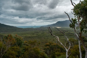
The next morning we were up early, keen to get to Roaring Meg campground and claim a spot before the rest of the hoards got there. We set off from Oberon Bay, with a snack stop at the peaceful Halfway Hut. There is camping available there, as well as a rainwater tank. From there it’s a steady climb up Martin’s Hill, but we were rewarded with some great views of the valley and coastline from where we had just come.
From there you have a choice of taking the walking track or the vehicle track. The walking track is slightly longer but more interesting and scenic, so if you have the time and the energy to tackle the fairly steep descent, we recommend taking that route. We arrived at Roaring Meg well before the estimated time. Roaring Meg is a peaceful site with two levels, the upper level being more open and close to the drop toilets (handy after that morning coffee), and the lower level being more vegetated and close to the river. We headed to the lower level and were scouring for the perfect campsite just as a lone camper was packing up his idyllic spot right by the river. We were quick to claim it.
Still having much of the day ahead of us and being able to leave our main packs behind to lighten our load, we set off for the southern point, which took a good 30-45 minutes longer than the estimated time. But it was really just a small delay to reach the point that we pined over for so long: the southernmost point of mainland Australia!
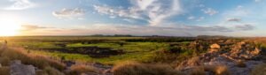
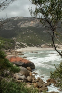
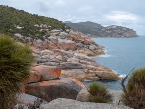
We could officially check off another compass point, one that took a bit more effort to reach than the one we had basically happened upon by accident. We spent a fair amount of time admiring the rugged coastline with its lichen-stained boulders and gazing out across the Bass Straight, squinting to see if we could catch a glimpse of Tasmania (as if we could!).
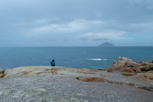
At one point, we saw distant splashes of water and although we weren’t sure, we are fairly certain that it was a humpback whale. It worked out well that for the time we were there, which could have been an hour, maybe two, maybe more (time seemed to not matter for a while), we were the only ones out on that point. It was pretty cool to look out across the coastline and know with certainty that there was no one further south on mainland Australia than us at that point in time. Eventually we decided that it was time to head back to camp, and we enjoyed our dinners with some extra company from a wallaby who emerged from the nearby bushes, not at all fussed by our presence as he ambled about, eating his own dinner from the surrounding greenery.

DAY 3
Our next day was dedicated to trekking to the lighthouse. We were very thankful to not be encumbered by the weight of our full packs, as the track is fairly undulating as it traverses through the bush out to the southern coastline before heading east to the lighthouse, with some great outlooks along the way.
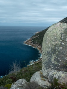
I feel for the hikers who trek all the way to the lighthouse to spend the night there, only to be greeted by an insanely steep climb as their final hurdle to make it to the cabins…but in return they have a proper bed, so can’t feel too sorry for them! The lighthouse is a pleasant place to stop, with a small museum detailing its history which also acts as a nice respite from the winds that often blow there. The on-site rangers are friendly, albeit interesting characters, who are keen to offer any more information that you may want to know. We were lucky in our timing in being able to join on a tour to the top of the lighthouse; great views ensued.
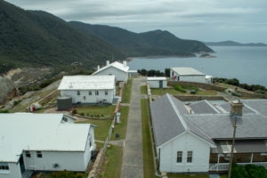
Keep an eye out for local wildlife; we saw a couple of seals sun baking on the rocks below, and one of the rangers confirmed that a whale was spotted swimming west the previous day, likely the same one we saw splashing about on the southern point.
DAY 4
Now there was one thing that had been looming in the back of our minds for the entire trip; the forecast for our last day was bleak. High chance of rain and thunderstorms, with the temperature dropping to mid teens. When chatting with one of the rangers at the lighthouse, he had assured us that the forecast had improved and it was actually going to an even nicer day than that one. Now, I don’t want to accuse anyone of misinformation but…
We woke up the next morning to dark, ominous skies. After our usual breakfast routine, we began our pack up just as drops began to fall. By the time we had finished packing up, the rain was heavy and steady. It took all of 5 minutes for my pants to be completely soaked through, the rest of my clothes and pack quickly following. We chose to take the vehicle track because although it was less scenic than the walking track, it was slightly quicker. For the first half of our 12 km hike, the rain came and went but from then on it stayed consistent for the rest of the hike to Telegraph Saddle; I’ve never been so wet while clothed. It was a feeling of pure relief reaching Telegraph Saddle and seeing the shuttle ready to take us back to a hot shower and dry clothes; however, the persistent rain didn’t dampen the feeling of accomplishment in successfully completing our first multi-day hike and reaching another compass point of mainland Australia.
Tips for hiking to the Southern Point of Wilson’s Promontory
⁃ Weather: weather is temperamental and unpredictable in Wilson’s Prom, so be ready for any weather, particularly windy and wet. Make sure you have enough water in case the rain tanks are empty. Running water is available at Roaring Meg but treating the water before drinking is advised
⁃ Wildlife: Wilson’s Prom is chock full of wildlife, including kangaroos, wombats, echidnas, and more. Be aware of where you keep your food, as well as rubbish, so the locals don’t have the opportunity to get into them.
⁃ Walking times: we found that the estimated walking times on the official Parks Victoria map were fairly inaccurate; most were over-estimated but some were under-estimated as well, so take that into account when planning
⁃ Campsites: Booking is required for any camping in the southern part of Wilson’s Prom, and it’s a maximum of 2 nights per booking, so try to get to campsites early to score a good spot as it will be quite likely that people from the previous night will have moved on
Thanks for reading; any questions or comments, let us know below!