While Karijini National Park is often the highlight of most peoples’ trips to the Pilbara, there are many more places in this massive region of Western Australia that are worth a visit. Following what has become known as the Warlu (“sea serpent”) Way from Exmouth to Broome will take you to both inland and coastal gems.
Starting from Exmouth, Onslow is an easy day’s drive away. We found a delightful free camp at Old Onslow along the banks of the Ashburton River. Be aware, however, that salties have been spotted in this river in the past, so swimming is not advised!

From here its a short drive to Old Onslow, where you can see remnants of the old township. The town was relocated in the early 1900s after two subsequent cyclones destroyed the jetty, and both the jetty and the township were moved 18km east. Onslow is a small and quiet town, with a nice coastal walk where you can see the salt mine and a couple little beaches. If you have a boat and/or an extra bit of coin (which we unfortunately didn’t), the Mackerel and Montebello Islands have rave reviews.
From Onslow you have the option of taking the coastal or inland route to Karratha. We took the inland route to Karijini then began to head north via Millstream Chichester National Park. For the road from Karijini to Millstream Chichester, you will need a permit from a regional info centre (we got ours at Tom Price) which consists of a donation to the RFDS and watching a 20 minute safety video as it is an active mining road. Millstream Chichester often gets overshadowed by the more popular Karijini, but there are still some beautiful spots to see, with less crowds to top it off. For camping, the options are Miliyanha and Stargazers campgrounds. Miliyanha is the bigger and more popular campground; it has more shade than Stargazers but generators are allowed, so if you’re after more peace and quiet, Stargazers is probably the better option. The 20km Snappy Gum scenic loop is a lovely, winding drive through the park. For swimming options, Deep Reach Pool (Nhanggangunha) is nice and close to camp, while the more well-known Python Pool is a bit further of a drive but well worth the trip to see this beautiful pool surrounded by towering red rock.
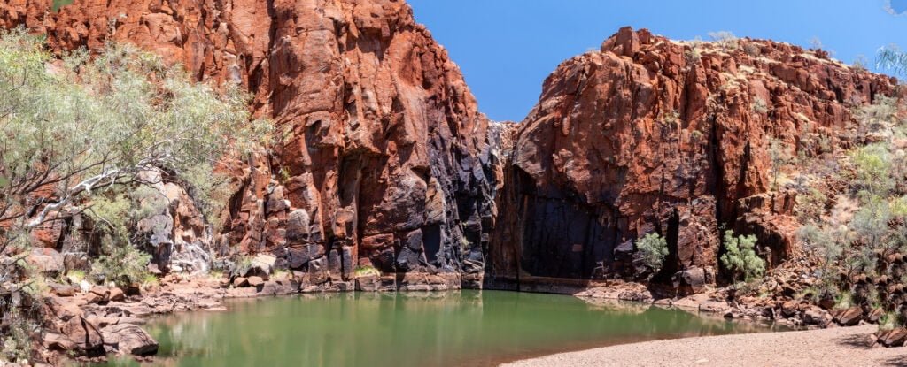
Be aware that algal blooms are common towards the end of the dry season so check before heading out if visiting during this time of year. On the way to Python Pool, you can do the short and steep climb to the top of Mount Herbert for great views over the Pilbara countryside.
Next stop on the Warlu Way is the coastal town of Karratha. Being one of the biggest towns of the Pilbara region, it makes a great opportunity to restock. Be sure to head out to Hearson Cove and Murujuga National Park (Deep Gorge) for an “outdoor gallery” of one of the largest known collections of aboriginal rock art in the world.

Again, with a boat or and extra bit of coin (which we still didn’t have), the Dampier Archipelago has more than 40 islands and islets to explore, some which allow camping for up to 5 nights. 20km west of Karratha is the town of Dampier, where you can find the memorial to the infamous Red Dog and read all about his fascinating story. Continuing west from Karratha, you’ll find Cossack and Point Sampson. Cossack, at present-day a ghost town, used to be a pearling epicentre until Broome took over. There is a great beachside free camp just out of town, but watch out for sandflies!

Nearby Point Sampson is a cute seaside town with some lovely beaches, like the pleasant Honeymoon Cove, and delicious fish and chips!

Port Hedland, the other major regional town of the Pilbara, is next up. Being a predominantly industrial town, it’s not exactly a picturesque tourist spot. Nevertheless it made a good place to do a last minute stock-up before we headed south to the town of Marble Bar. Almost 200km south of Perth Hedland, Marble Bar is known as the hottest town in Australia, which, considering Australia is the hottest continent on Earth, makes that claim quite an achievement. This town once experienced 160 consecutive days where the temperature didn’t go below 38 degrees Celsius! Marble Bar is named for the abundance of colourful rock in the area, which was once thought to be marble but is actually jade. One of our main reasons for visiting was to take a trip down memory lane for Marc, from his family trip around Australia when he was 4 years old. Just like he did as a kid, we took a bucket of water down to the rocks to pour over them to bring the colours out; it is quite pretty!

The other reason we ventured down this way was because of a fellow traveller’s recommendation. Heading east from town is a 340-ish km 4WD loop that takes you to some really off-the-beaten-track spots. It can be done in a day, but if you have a bit of spare time and a tent or small trailer, there are some great camping options along the way. Highlights include Carawine Gorge and the incredibly clear water of Running Waters Spring.


Keep an eye out for the sign to Skull Springs (you’ll get it when you see it!). The day we did this drive, by early afternoon we could see storm clouds rolling around with the occasional lightning strike. Then little plumes of smoke started to appear, seemingly all around us, including a bigger one very close to where we had left our van for the day. We rushed home, driving through the occasional bushfire, relieved to have confirmed on our arrival that the smoke we had seen was still a ways away from our van. Despite this we hitched up, ready for a quick getaway at a moment’s notice. Luckily, just as the fire was starting to get a bit close for comfort, a decent rainstorm came through and put everything out…it would have been a pretty sleepless night otherwise!
The next day we headed back to the coast and parked up at the beautiful clifftop camp at Cape Keraudren for the night. We had our first experience with the massive tides that occur in this part of the world, as well as our first view of the staircase to the moon. It was very windy, though!

The following day we opted to travel on, originally planning to stay at the caravan park at 80 Mile Beach, which has beautiful beachside camping, but instead (for reasons completely unrelated to the caravan park) we had to stay at Sandfire Roadhouse along the highway instead. It was no beachside camp but still actually pretty good…there are plenty of entertaining animals milling about, including camels and peacocks that came right up to us at the van!
Long before we got to the Pilbara region, we had heard of a place called Barn Hill Station, which apparently has excellent camping and not usually too many people. Unfortunately with us travelling through at the end of the dry season, the station was closed until next year by the time we got there. Hopefully we’ll get to it one day! This, however, meant we got to Broome a lot quicker than expected, where we planned to stop for work and experience our first ever North Australian wet season!
